
This particular map was one that I'd gone to a lot of effort to create, inspired by those lovely maps for the Greyhawk and Forgotten Realms settings. This map is intended to represent a huge peninsula attached to a much larger continent (if you look near the upper right corner you can see where the map continues off the page).

Click to expand maps
This map is not quite finished, I left a few areas blank so that I could fill them in later once I'd decided what I wanted to go there. There's large blank chunk of land in the lower right corner that represents a part of the main continent, and something that could be a large island or peninsula. There's also a small blank island in the upper right quadrant. More on that later...
The map was sketched out on a large sheet of heavy paper with a pencil. I went back over the pencil lines with a fine Rapidiograph technical pen. The colored areas were done with marker pens (hence the stripey look).
The areas in light green represent light forest, the areas in dark green are heavy forest. Light blue represents shallow water, and dark blue represents deeper waters (some river areas are also very deep). The orangey areas are desert, and the grey areas are mountains (some of which have snow). There are also some light green hills drawn in over the grassy areas, representing rolling hills.
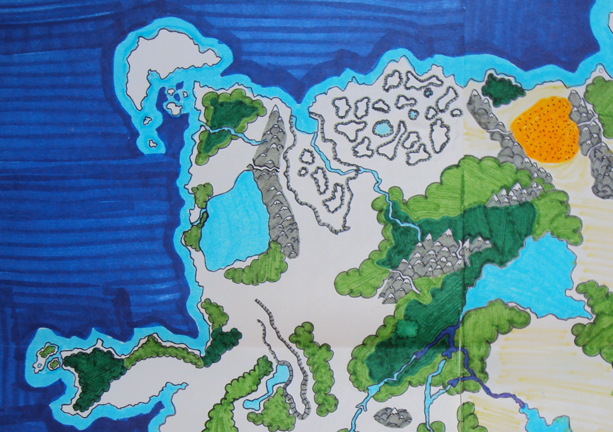
This section of the map shows the upper left quadrant in greater detail. The upper center section has an area of canyons and badlands (the area with the elevation lines). The lower right section shows the large forested mountain area in the center of the continent, and the large sea that it wraps around. There is another large sea or lake near the west coast, and below that is a forested peninsula.

This shows the lower left quadrant of the map. There's a large forest to the south, with a river delta that flows through the woods and empties into the southern coast. There's a ring of mountains with a blank center (not sure what I was going to put inside it) near the center of this map. There's also an improbably desert surrounded by forest areas. Oops!

Here's the lower right quadrant. There's a volcano near the top/center of the map (note the smoke coming out of it), and a forest with a marshy coastline on the east coast of this landmass. Toward the west, the two large inland seas are visible. The white areas were left blank to be filled in later, but are supposed to be connected to the main continent that this peninsula is attached to.

This is the lower right quadrant, and you can see where it connects to the larger continent in northeast. Most of the interesting features have already been mentioned, but there is a small mountain pass drawn through the mountain range in the center of the map. I think that was originally supposed to be a dwarven outpost where they offloaded stuff from the bay and routed it through the pass.
A lot of work went into this map. While I'm not terribly happy with it, I do think that it looks great. This was intended to be a player map, something that they could touch and see, to help them visualize the game world. I planned to use the transparent hex overlays that came in the TSR boxed sets to measure distances, but this map never ended up being used, and was stored away for almost 20 years.
If you want to try a map like this, make sure you have a lot of markers because it takes a lot of ink to fill in those large areas.
:)
No comments:
Post a Comment